STATISTICS

Start Year: 1995
Current Year: 2004

Month: April

2 Weeks is 1 Month
Next Month: 28/04/2024

OUR STAFF

Administration Team

Administrators are in-charge of the forums overall, ensuring it remains updated, fresh and constantly growing.

Administrator: Jamie
Administrator: Hollie

Community Support

Moderators support the Administration Team, assisting with a variety of tasks whilst remaining a liason, a link between Roleplayers and the Staff Team.

Moderator: Connor
Moderator: Odinson
Moderator: Vacant


Have a Question?
Open a Support Ticket

AFFILIATIONS

RPG-D

[Australia]: Alpine Firestorm

Owen

Commonwealth of Australia
GA Member
Jul 2, 2018
2,732

8 JANUARY 2001
AUSTRALIAN ALPS, VICTORIA AND NEW SOUTH WALES
32 DEGREES CELSIUS ABOVE 1000M
38 DEGREES CELSIUS AT SEA LEVEL


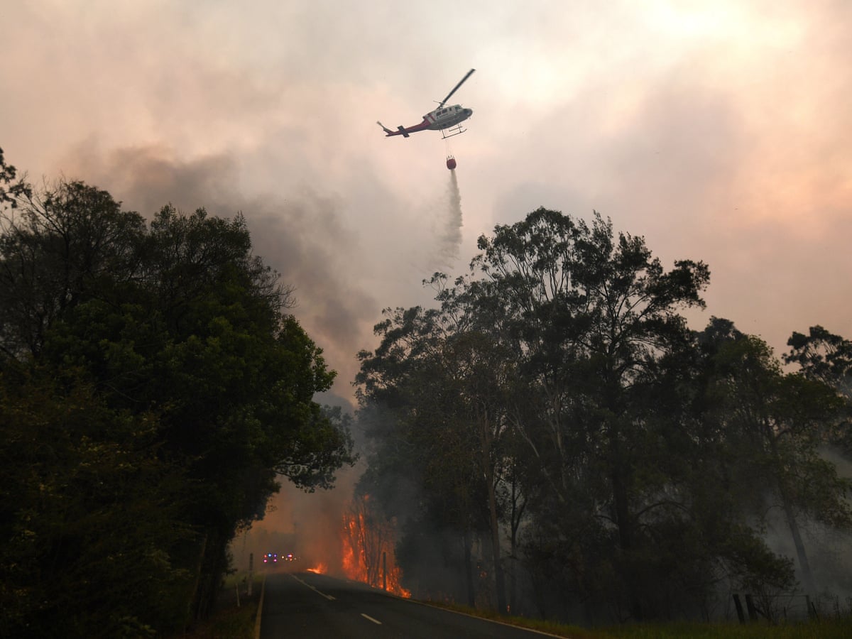
Usually the home of ski resorts in Australia, the middle of summer would see the Australian Alps turn into a warm defrosted wilderness, with usually much cooler temperatures than sea level. Things were starting to get hot on the sea level though and as a result, up in the mountains as well. Temperatures that they usually don't see, above 30 degrees celsius. Summer creates all types of weather conditions and after quite a hot day in the Alpine areas, a storm would begin rolling across Victoria, developing through tropical moisture being dragged from the north of Australia through a frontal trough. It would blanket the cities of Melbourne and Canberra in heavy rainfall and thunderstorms, but the temperature didn't shift much, still staying relatively warm and humid. It would also create thousands of lightning strikes everywhere in between, throughout the Victorian Alps and Southern New South Wales. Spot fires would begin to start in high elevations, elevations which were extremely difficult for fire fighting. 87 fires in total would start in Victoria across the Alpine National Park and the Mount Buffalo National Park and 4 fires would start in New South Wales in the Brindabella National Park, just north-west of the Australian Capital Territory and 1 significant one would start in the locality of Yambulla near the Victorian border. Due to the rugged terrain, local fire crews from the Country Fire Authority in Victoria, the Rural Fire Service in New South Wales, the Forest Fire Management Victoria, the New South Wales National Parks and Wildlife Service and the ACT Rural Fire Service in the Australian Capital Territory would find it difficult to reach them. Trucks would be sent up to high elevations, through windy roads and roads which were cut off due to trees falling down in the storm. Aircraft would be predominantly used to attempt to extinguish the fires. Helicopters from the CFA and the NSW Rural Fire Service would begin waterbombing operations in an attempt to extinguish the fires.

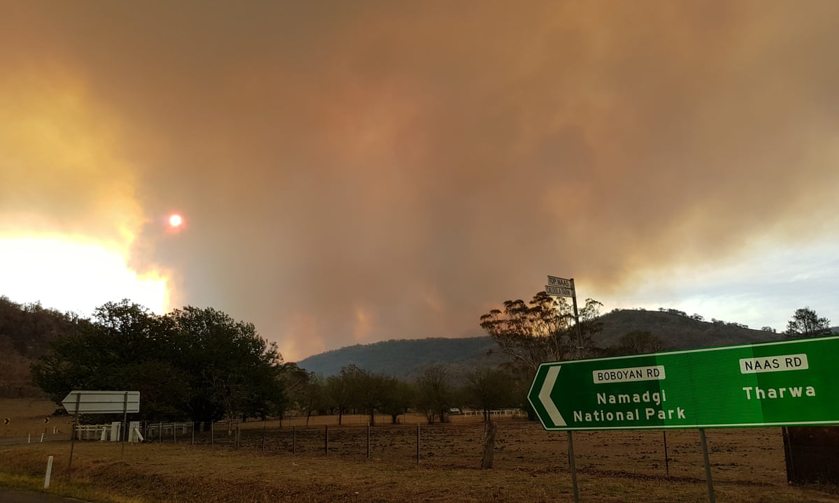
At the moment, the Yambulla fire would pose the most significant threat to lives and property as the other fires were not as fast moving and were in uninhabited areas. Significant resources from District 11 of the Country Fire Authority, the NSW Rural Fire Service, Forest Fire Management Victoria and the New South Wales National Parks and Wildlife Service would be sent to the fire as it crossed the NSW-Victorian border heading towards the Victorian towns of Maramingo Creek and Genoa as well as the larger but further town of Mallacoota. A Watch and Act warning would be in place for people in the areas of Maramingo Creek and Genoa and an Emergency Warning for people in the proximity of the Yambulla State Forest and the Maramingo Creek Nature Conservation Reserve.


Owen

Commonwealth of Australia
GA Member
Jul 2, 2018
2,732

13 JANUARY 2001
AUSTRALIAN ALPS, VICTORIA AND NEW SOUTH WALES
CANBERRA AND THE AUSTRALIAN CAPITAL TERRITORY
35 DEGREES CELSIUS ABOVE 1000M
41 DEGREES CELSIUS AT SEA LEVEL


By now the fire front was beginning to expand. In the Victorian Alps, 8 of the 87 fires which were started would begin to grow out of control across the Alpine National Park. They would still rage within the sparsely populated and difficult terrain of the Alps and so the resources or attention to the fires would be minimal. The Yambulla Fire which was threatening towns in the far east of Victoria would now be contained by the Country Fire Authority and would no longer pose a threat. Emergency Warnings would be in place for many small towns in the fire zone such as Omeo, Bright, Hotham Heights, Mount Beauty, Glen Valley, Wulgulmerang and the Falls Creek Alpine Resort in Victoria as well as New South Wales towns of Khancoban, Jindabyne and the Alpine Resorts of Thredbo, Perisher Valley and Charlotte Pass. Evacuation centres would be set up on both sides of the Alps in Victoria, one at Beechworth and one at Bairnsdale. The New South Wales evacuation centre would be at Cooma. So far no injuries or deaths would be reported and the fires would be for the most part, avoiding lives and properties, continuing to rage in the altitudes above 1000 metres. Victoria and New south Wales Police would have major road closures in place across the Alpine Region and the Victoria and New South Wales State Emergency Services would be assisting with evacuations and running evacuation centres.

For fire authorities however, the more pressing fires were the one burning north of the Alpine complex, one in the Brindabella National Park of New South Wales, north-west of the Australian Capital Territory and two in the Namadgi National Park/Tidbinbilla Nature Reserve of the Australian Capital Territory straddling the border with New South Wales. The ACT Chief Minister, Katy Gallagher and ACT Chief Fire Control Officer, Peter Lucas-Smith would be taken up in the Snowy Hydro SouthCare Helicopter to investigate the fires. Nearby to them would be a waterbombing Bell JetRanger helicopter. While collecting water from the Bendora Dam in the ACT, the helicopter would crash into the water. There was one person onboard, the pilot, Duncan Patrick. The helicopter would begin to sink into the water and he would be unconscious. The SouthCare helicopter caring the Chief Minister would hover over the wreckage. Paramedic Euan McKenzie who was onboard the helicopter would go in and free the helicopter pilot and would attempt to lift him into the SouthCare helicopter. However the weight of his clothes and lack of life vest he would be too heavy to be winched up. The SouthCare helicopter would lower down and allow Katy Gallagher and Peter Lucas-Smith to jump into the water. All three would begin to drag the helicopter pilot 60 metres to shore. There he was resusitated by Peter Lucas-Smith and Euan McKenzie as Katy Gallagher looked on.

An Emergency Warning message would be present for people in the Brindabella and Uriarra area of New South Wales and the Cotter River, Coree and Uriarra Village area of the Australian Capital Territory. Australian Federal Police ACT Policing Division and the New South Wales Police Force would begin road closures in the area, notably the Brindabella Road between Cotter Road in the ACT and the Bondo State Forest in NSW, the Mountain Creek Road between Uriarra Road in the ACT and Wee Jasper Road in NSW and Corin Road between Tidbinbilla Road and Corin Dam in the ACT. Lower Cotter Catchmnet Nature Reserve, Tidbinbilla Nature Reserve and Namadgi National Park would all be closed to visitors. Fire authorities from the New South Wales Rural Fire Service, the New South Wales National Parks and Wildlife Service, the ACT Rural Fire Service, the ACT Fire and Rescue and the ACT Parks and Conservation Service would continue to battle the three major fires threatening Canberra.

NSW Rural Fire Service, ACT Rural Fire Service, ACT Fire and Rescue, Australian Federal Police ACT Policing and ACT State Emergency Service convoy assembling in Central Canberra


Canberra being blanketed in smoke


Bushfires on the outskirts of Canberra with Parliament House in the foreground


NSW National Parks and Wildlife Service firefighter in the Brindabella National Park


Australian Federal Police ACT Policing maintaining a road block on the outskirts of Canberra
 
Last edited:

Owen

Commonwealth of Australia
GA Member
Jul 2, 2018
2,732

17 JANUARY 2001
CANBERRA AND THE AUSTRALIAN CAPITAL TERRITORY
36 DEGREES CELSIUS


The fires straddling the ACT-NSW Border would continue to burn for several days without much major movement, however the difficult terrain and lack of firefighting resources meant that the fires were still very much burning. The 17th of January would bring a weather change, winds would begin to blow in an easterly direction at about 40 knots. This would mean the three fires would begin significantly moving towards Canberra. The two fires in the Namadgi National Park would begin ripping across the park, with high fuel loads ensuring that their movement was ferocious. ACT Parks and Conservation Service and ACT Rural Fire Service firefighters would retreat from the park, the entire park would now be closed along with the Tidbinbilla Nature Reserve. The furthest south of the three fires would begin getting dangerously close to the settlement of Tharwa and an emergency warning would be in place for that area, residents would evacuate Tharwa to evacuation centres in Canberra. There was concerns that numerous structures had been destroyed in the Namadgi National Park, including ranger stations. The middle fire would not burn as far as the furthest south one but would now begin approaching the Murrumbidgee River. There would be concerns for the Canberra Deep Space Communication Complex and all CSIRO staff would be evacuated from that premises. The most northern fire, burning in the Brindabella National Park of NSW would cross the border into the ACT and would begin threatening the village of Uriarra. An emergency warning would be put in place for Uriarra and Coree and people would be evacuated to Canberra. It was concerned that historical buildings like the Sherwood Homestead would be lost to the fire. A Watch and Act message would be in place for residents of the Canberra suburbs of Banks, Gordon, Bonython, Greenway, Kambah, Fisher, Chapman, Rivett, Duffy, Wright, Coombs, Denman Prospect, Molonglo and the localities of Stromlo and Paddys River. The ACT Chief Minister and all the fire chiefs of the ACT, including the NSW Rural Fire Service chief would meet in Canberra and would get no sleep as they await to see what January 18th held. The Prime Minister would be constantly updated as he stayed in The Lodge in Central Canberra. A Poor Air Quality warning would go out across the ACT.

Country Fire Authority strike team heading up from Eastern Victoria to assist in defending Canberra


Canberra Deep Space Communication Complex


Fire approaching the town of Tharwa


Parliament House shrouded in smoke
 

Owen

Commonwealth of Australia
GA Member
Jul 2, 2018
2,732

18 JANUARY 2001
CANBERRA AND THE AUSTRALIAN CAPITAL TERRITORY
40 DEGREES CELSIUS


The morning of 18 January 2001 was hot, windy and dry. Temperatures as high as 40°C and winds exceeding 80 kilometres per hour, plus a very low relative humidity, were the main weather features of the day. Two fires continued to burn out of control in the Namadgi National Park, with the entire park, along with the Tidbinbilla Nature Reserve, being closed due to the threat. A second fire, in the Brindabella Ranges, was threatening to break containment lines. By 9am on the morning of Saturday 18 January, burned leaves appeared on lawns in houses in the Weston Creek, Kambah, and Tuggeranong suburbs bordering the western extremity of Canberra. By 10am, news helicopters were overflying Duffy and reporting news of the fires interstate and internationally, but no news was available locally. Throughout the day, the fires burned closer to the fringes of Canberra's suburbs, and there was no sign of authorities gaining control of the situation. At around 2pm, police evacuated the township of Tharwa to the south of Canberra. By mid-afternoon, it had become apparent that the fires posed an immediate threat to the settlements near Canberra, such as Uriarra and Stromlo, as well as to the houses on the city's urban-bushland interface. A state of emergency was declared at 2.45pm by the ACT's Chief Minister, Katy Gallagher.

The fires reached the urban area at 3pm. The first emergency warning advisories were broadcast shortly after, on radio and television, with the advisories updated throughout the day. These advisories, accompanied by the Emergency Warning Signal stated that a significant "deterioration" of the fire situation in the ACT had occurred and placed several suburbs on alert to evacuate. As the day continued, these advisories advised the evacuation of several suburbs (also enforced by Police on the ground) and placed most suburbs of Canberra on some level of alert. By now, the fire had reached the fringes of many suburbs, was surrounding Tharwa, and threatened the historic Lanyon Homestead, which was hosting a wedding and protected by only a single fire truck.


"Julie Derrett with you on Triple 6 ABC Canberra, you can't miss it the bushfires are worsening around the ACT, there's an awful lot of smoke around the area, stay with us throughout the afternoon and we will keep you up to date. Mark Jennings, one of our Triple 6 program producers is out in his car and he has a report for us. Mark what are you able to see? Where are you?"

"Out near Ginnindera Falls Julie, you can probably hear the wind going through the phone it's belting through."

"And what can you see where you are Mark?"

"Across the Molonglo slash Murrumbidgee the flames are a good three.... four times the size of the trees and there's a couple of fire fronts and they seem to be burning against the wind sort of coming towards the northern side but if you look back across the city I can't even see Telstra Tower from here."

"How far away is that from any residential area?"

"I don't think its gonna be too long before they're there, it's not that far."

The ABC would play the Emergency Warning signal.

"The signal you can hear now is the Emergency Services Bureau signal which means we have an important alert to bring you...

This is an official Emergency Services announcement, the ACT Emergency Services Bureau has advised that there has been a major deteroriation in the ACT fire situation. There is increasing risk due to fire spotting from the fires towards the west."


By 3.50pm, some houses were alight in the suburbs of Duffy and Chapman, with the loss of a home in Holder soon after. An ACT Fire and Rescue unit, perceiving the fire from a vantage point in Fyshwick, overrode instructions by the radio controller to ignore the signs and remain where they were. The unit headed to Duffy, attempting to alert both controllers and residents to the imminent danger. That unit was caught in a fire front on Warragamba Avenue, Duffy at around 4.10pm, after having rescued at least two residents. Both the crew and residents were forced to flee the appliance when the fire struck. Due to fire damage to infrastructure and extreme winds bringing down powerlines across the area, large parts of the city lost power. Fires also started in Giralang because of powerline problems. Evacuation centres were set up at four schools: Canberra College, Lake Ginninderra College, Erindale College and Narrabundah College. A dark cloud hung over the city, and, although it was not in danger, Parliament House was closed. By 5pm, houses were reported destroyed in Duffy, Chapman, Kambah, Holder, and Rivett, as well as in the small forestry settlement of Uriarra. It was later found that the first casualty of the fires, an elderly woman named Dorothy McGrath, had died at the nearby Stromlo Forestry Settlement. Escape for residents was hampered by poor warning and by the settlement's location, surrounded by the pine forest. Fires in the Michelago area forced the closure of the Monaro Highway into Canberra. Fires spread through the Kambah Pool area and into the suburb of Kambah, causing damage to many homes and one of the ACT's primary Urban and Rural fire stations.

Fire spread through parkland, crossing the Tuggeranong Parkway and Sulwood Drive finally engulfing Mount Taylor. Within an hour, houses were also burning in Torrens, on the slopes of Mount Taylor, and in Weston.As the fire made its way through the Mount Taylor Nature Reserve and Farrer Ridge Nature Reserve, it was becoming clear that the Ethiopian and Vietnamese Embassies could be at risk if the fire made its way up the Mount Mugga Mugga Nature Reserve, certainly of ember attacks at least. The Australian Federal Police would send units out to those embassies. They would advise them that the fire was approaching though they had no advice for them to evacuate at this stage, but just to prepare themselves for a potential evacuation (Naio90 HeadlessSeeker). The fires by now had inflicted severe damage to the city's infrastructure. Power supplies were cut to several suburbs. These outages affected both the Emergency Services Bureau's own headquarters in Curtin and the Canberra Hospital (running on back-up generators), which was under intense pressure from people suffering burns and smoke inhalation.

In Curtin, the ESA headquarters was in danger from the fires. With back-up power available only to the Communications Centre, many personnel were forced to work on tables outside as Army Reserve personnel hosed down the building. Water, gas, sewerage, and communications were heavily affected. Water, gas, and landline communications was unavailable to several suburbs due to damage to supply lines and city reservoirs. Mobile telecommunications were severely affected due to increased traffic, causing serious disruption to mobile phone networks and the ESA's own radio and dispatch networks. A local generator services business later reported on their website that the ash and smoke were so intense, that some back-up power diesel generators at communication and data centres failed to produce enough power due to air intake filters clogging up. At least one generator air intake filter burned as it sucked in burning leaves blowing in the strong winds. As the fire began to make its way across the Tuggeranong Parkway and the Molonglo River towards Curtin it would begin threatening Government House and also the Portuguese Embassy. Government House would have several fire truck resources deployed to it, as a priority 1 site to protect. Several fire trucks would be in the vicinity of Curtin, Deakin and Yarralumla putting out spot fires. The Australian Federal Police would send units over to the Portuguese Embassy (Bruno) and the Nigerian High Commission (Baer) ordering them that it was now time to evacuate and to do it immediately with the fire front only 1 and a half kilometres away. Fire trucks would position themselves along Yarra Glen to fight the incoming fire. Embers would be ferociously blowing over Curtin and Deakin, some would eventually land on the roof of the Portuguese Embassy. Fires would now begin breaking out on the roof of the Portuguese Embassy, igniting leafs and other materials in the gutters. Fire would begin spreading through the roof. With all the staff now evacuated the Australian Federal Police there would radio it in.

"FIRE ON THE ROOF OF THE PORTUGUESE EMBASSY, 32 THESIGER COURT DEAKIN. CAN WE HAVE A UNIT DOWN HERE?" However the fire authorities were stretched thin trying to stop the fire front from getting any closer to Deakin. The fire would quickly spread through the roof and eventually into the main building of the Embassy. Police would watch as there was nothing they could do. Eventually firefighters would arrive on foot from fire trucks positioned along Yarra Glen and would attach a hose to a hydrant and begin dousing the flames.

A couple of trucks would be positioned on Novar Street, Yarralumla and would be the last line of defence for the Nigerian High Commission. They would hold the fire front back, which would struggle to find a way of making its way through the narrow strip of vegetation between Adelaide Avenue and Guilfoyle Street, however several homes along Denman Street would be damaged or destroyed by fire before it eventually came to a stop by ACT Fire and Rescue authorities working in Yarralumla.

The fires impacted part of the Lower Molonglo Water Quality Control Centre, responsible for treating the city's sewage and waste water before its release into the Molonglo River. The plant's operations were disrupted due to fire damage, causing concern about the possible release of sewage into the Molonglo River, as the plant's reserve storage could only hold one day of surplus. By 10pm, one of the four evacuation centres in Canberra was completely full, and the others were filling up quickly. Reports of looting also began to arrive from the damaged areas. Both Prime Minister Kim Beazley and Governor-General Dame Quentin Bryce changed their plans to return to Canberra as soon as was possible. While the very worst of the fires had passed, the situation was still far from stable, and going into the 19 January, houses were still ablaze across numerous suburbs.

WIN Canberra News coverage of the fires


Fire crossing the Tuggeranong Parkway with Telstra Tower in the background


Houses being destroyed in the suburb of Duffy


A fire tornado, the first ever of its type recorded in the world


A Helicopter waterbombing homes in the suburb of Chapman
 
Last edited:

Naio90

Federal Republic of Ethiopia
Contributor
Jul 1, 2018
4,311
The ethiopian Embassy in Canberra would receive the alert from local authorities and put in place its contingency plan by reducing personnel to a minimum and voluntarily evacuating the rest to a safer location. Before doing this, they would take all essential documents, sensible information and hard disks with information with them, securely stored in diplomatic bags (clearly marked as such). Access to the ethiopian intranet and host servers in Ethiopia would also temporarily be interrupted.​
The remaining staff, including the ambassador would remain alert and ready in case they would need to conduct a full evacuation.​

Owen
 

Naio90

Federal Republic of Ethiopia
Contributor
Jul 1, 2018
4,311
With no news from the australian authorities and no further signs of increased threat, the ethiopian ministry of foreign affairs would consult with the ethiopia diplomats in Australia wheter the situation would allow for a return to normal operations at the Embassy in Canberra.

Having checked and verified the situation, the decision would be made to reopen the diplomatic representation and reusme all consular services to the public. However, a direct line of communications would be mantained with the local australian authorities in case the threat of the wildfires returns.

No damage to ethiopian property and ethiopian citizens would be registered during the incidents.
 

Owen

Commonwealth of Australia
GA Member
Jul 2, 2018
2,732
The Canberra Bushfires would conclude with 4 deaths, 435 injuries and 488 buildings being destroyed across the Australian Capital Territory. By the evening of 19 January, it was clear that the worst-hit suburb was Duffy, where 200+ residences were destroyed, and that four people had died: Alison Tener, 38, Peter Brooke, 74, and Douglas Fraser, 60, and Dorothy McGrath, 76, of the Mount Stromlo Forestry Settlement. The loss of life, damage to property, and destruction of forests to the west of the city caused not just economic loss but significant social impacts. Bushfires severely harmed the vegetation of the Cotter River Catchment and caused water quality problems in the three dams in the catchment: Corin, Bendora and Cotter Dams. For quite some time after the fires, turbidity in the water due to silt and ash from surrounding burnt-out forests meant Canberra had to rely on Googong Dam on the Queanbeyan River, which was not affected by the fires. Given the drought and existing water shortages, this effectively reduced Canberra's water reserves to around 15% for some time. An upgrade to the Stromlo Water Treatment Plant was subsequently required to allow extra filtration of water to cope with the diminished quality in the future.

Perhaps the most notable cultural and scientific loss caused by the fires was the damage to the scenic and renowned Mount Stromlo Observatory (headquarters of the Research School of Astronomy & Astrophysics of the Australian National University), which is estimated to be the source of a third of Australia's astronomical research. Five historically significant telescopes were destroyed. Instrumentation and engineering workshops, the observatory's library, and the main administration buildings were consumed. The visitors' centre or "Exploratory" housing public exhibits and cafe escaped the fires unscathed, despite being on the edge of a steep gradient, which fires had roared up, and being only metres from the 74-inch telescope, which was completely destroyed.

For the more broader Alpine Bushfire situation, the main fire burnt over 1,300,000 hectares over 59 days before it was contained on 7 March 2001. 41 homes and 213 other structures were destroyed outside of the ACT in New South Wales and Victoria, along with tree bridges, and 10,000 livestock were killed. Thousands of kilometres of fencing was also destroyed. This was the longest running fire in Australian history.

 
Top