

- Jul 2, 2018
- 3,723
Queensland

Severe Tropical Cyclone Monica originated from an area of low pressure that formed early on 16 April 2006 off the coast of Papua New Guinea. The low quickly became organised, with deep convection developing over the low-pressure centre. Early the next day, the Bureau of Meteorology in Brisbane declared that the low had developed into a Category 1 cyclone on the Australian tropical cyclone scale, with winds reaching 65km/h. Upon being classified as a cyclone, the storm was given the name Monica. Monica tracked generally westward, towards Far North Queensland, in response to a low to mid-level ridge to the south.
Low wind shear and good divergence in the path of the storm allowed for continued intensification as continued westward. Late on 17 April, Monica intensified into a category 2 cyclone, with winds reaching 95km/h. By the 18 April, the Bureau of Meteorology upgraded Monica to a severe tropical cyclone, a Category 3 on the Australian scale. This followed an increase in the storm's outflow and a fluctuating central dense overcast.
Upon being declared as Tropical Cyclone Monica on 17 April, the Bureau of Meteorology issued a gale warning for areas along the eastern coast of Far North Queensland and for northern New South Wales. Several hours later, a cyclone warning was issued for north-eastern areas as the storm intensified. An estimated 1,000 people were planned to be evacuated in Far North Queensland before officials shut down major highways in the area. Ferry services in the Great Barrier Reef and flights in and out of the region were cancelled. However, no evacuations took place according to the Emergency Management Australia. An Aboriginal Community of 700, located around the mouth of the Lockhart River, were in the direct path of the storm. The chief executive officer of the community stated that they were ready for the storm, having suffered no losses from Cyclone Ingrid which impacted the same area in 2005.
During the afternoon of 19 April, the storm made landfall roughly 40km south-southeast of the Lockhart River with winds of 130km/h.

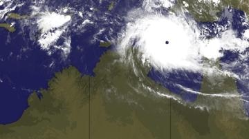
Cyclone Monica making landfall in Far North Queensland
Shortly after making landfall, convection associated with the storm deteriorated and the outflow became fragmented. A shortwave trough to the south caused the ridge steering Monica to weaken, leading to the cyclone moving slower. After moving over land, the storm began to weaken, with the Bureau of Meteorology downgrading the storm to weaken to Category 1 cyclone. The following day, Monica moved offshore, entering the Gulf of Carpentaria. Once back over water, favourable atmospheric conditions allowed the storm to quickly intensify. Within 24-hours of moving over water, Monica re-attained severe tropical cyclone status. Following a shift in steering currents, the storm slowed significantly and turned north-westward. Steady intensification continued through 22 April as the storm remained in a region of low wind shear and favourable diffluence. Early on 22 April the Bureau of Meteorology upgraded Monica to a Category 5 severe tropical cyclone, the third of the season. By this time, a 37km wide eye had developed within the central dense overcast of the cyclone.
Little damage was recorded in Queensland, despite Cyclone Monica being a Category 3 cyclone, as the storm impacted a sparsely populated region of the Cape York Peninsula. A storm surge of 1.23m was recorded in Mossman and waves were recorded up to 4.24m in Weipa. Heavy rainfall was also associated with the storm, exceeding 400mm near where Monica made landfall. Wind gusts up to 109km/h were recorded as the storm traversed the peninsula. Officials reported about 15 percent of the structures along the Lockhart River sustained minor damage. Minor coastal flooding was also reported due to Monica. Three Torres Strait Islanders were rescued after drifting at sea in the wake of the cyclone passing through the Torres Strait, north of mainland Queensland.
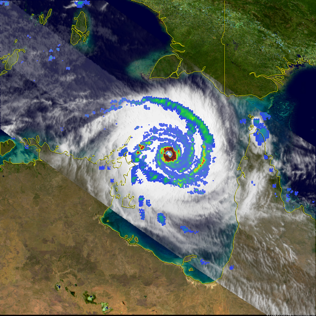
Rain radar of Cyclone Monica over the Gulf of Carpentaria
Severe Tropical Cyclone Monica originated from an area of low pressure that formed early on 16 April 2006 off the coast of Papua New Guinea. The low quickly became organised, with deep convection developing over the low-pressure centre. Early the next day, the Bureau of Meteorology in Brisbane declared that the low had developed into a Category 1 cyclone on the Australian tropical cyclone scale, with winds reaching 65km/h. Upon being classified as a cyclone, the storm was given the name Monica. Monica tracked generally westward, towards Far North Queensland, in response to a low to mid-level ridge to the south.
Low wind shear and good divergence in the path of the storm allowed for continued intensification as continued westward. Late on 17 April, Monica intensified into a category 2 cyclone, with winds reaching 95km/h. By the 18 April, the Bureau of Meteorology upgraded Monica to a severe tropical cyclone, a Category 3 on the Australian scale. This followed an increase in the storm's outflow and a fluctuating central dense overcast.
Upon being declared as Tropical Cyclone Monica on 17 April, the Bureau of Meteorology issued a gale warning for areas along the eastern coast of Far North Queensland and for northern New South Wales. Several hours later, a cyclone warning was issued for north-eastern areas as the storm intensified. An estimated 1,000 people were planned to be evacuated in Far North Queensland before officials shut down major highways in the area. Ferry services in the Great Barrier Reef and flights in and out of the region were cancelled. However, no evacuations took place according to the Emergency Management Australia. An Aboriginal Community of 700, located around the mouth of the Lockhart River, were in the direct path of the storm. The chief executive officer of the community stated that they were ready for the storm, having suffered no losses from Cyclone Ingrid which impacted the same area in 2005.
During the afternoon of 19 April, the storm made landfall roughly 40km south-southeast of the Lockhart River with winds of 130km/h.
Cyclone Monica making landfall in Far North Queensland
Shortly after making landfall, convection associated with the storm deteriorated and the outflow became fragmented. A shortwave trough to the south caused the ridge steering Monica to weaken, leading to the cyclone moving slower. After moving over land, the storm began to weaken, with the Bureau of Meteorology downgrading the storm to weaken to Category 1 cyclone. The following day, Monica moved offshore, entering the Gulf of Carpentaria. Once back over water, favourable atmospheric conditions allowed the storm to quickly intensify. Within 24-hours of moving over water, Monica re-attained severe tropical cyclone status. Following a shift in steering currents, the storm slowed significantly and turned north-westward. Steady intensification continued through 22 April as the storm remained in a region of low wind shear and favourable diffluence. Early on 22 April the Bureau of Meteorology upgraded Monica to a Category 5 severe tropical cyclone, the third of the season. By this time, a 37km wide eye had developed within the central dense overcast of the cyclone.
Little damage was recorded in Queensland, despite Cyclone Monica being a Category 3 cyclone, as the storm impacted a sparsely populated region of the Cape York Peninsula. A storm surge of 1.23m was recorded in Mossman and waves were recorded up to 4.24m in Weipa. Heavy rainfall was also associated with the storm, exceeding 400mm near where Monica made landfall. Wind gusts up to 109km/h were recorded as the storm traversed the peninsula. Officials reported about 15 percent of the structures along the Lockhart River sustained minor damage. Minor coastal flooding was also reported due to Monica. Three Torres Strait Islanders were rescued after drifting at sea in the wake of the cyclone passing through the Torres Strait, north of mainland Queensland.
Rain radar of Cyclone Monica over the Gulf of Carpentaria


