- Jul 2, 2018
- 3,668
Date: January 2008
Location: Radionuclide Station 10 (RN10), Perth, Western Australia
Geoscience Australia would work alongside the Australian Radiation Protection and Nuclear Safety Agency (ARPANSA) to operate a network of Radionuclide monitoring sites across Australia, originally established as part of Australia's obligations to enforce nuclear weapons test bans, particularly in the Southern Hemisphere. Geoscience Australia would be Australia's leading agency on geoscientific matters and research and would fall under the Department of Industry, Science, Energy and Resources. ARPANSA, however, was part of the Department of Health and was tasked with protecting Australians from both ionising and non-ionising radiation as well as being the regulatory for the use of radiation. After the abolition of nuclear weapons, these sites were repurposed into general particulate monitoring but still retained their radionuclide monitoring capability in order to ensure that Australians were safe from the effects of nuclear radiation. They form part of Geoscience Australia's wider Australian Man-Made Hazard Monitoring Network which also included sites that would detect infrasound, seismic and hydroacoustic explosions. Detections by the radionuclide sites were rare, the closest nuclear power station was in South Africa and it was only the one. Five were located in Argentina and Brazil but were distant enough. The southern latitudes of the Southern Hemisphere were known for their anti-trade winds, or "Westerlies". Winds predominantly moved from west to east, which made southern Australia prone to cold fronts fuelled by Antarctic air during the winter and would traditionally strike South-West Western Australia first.

The RN10 Station located in Perth would be the most westerly radionuclide detection site on Mainland Australia. There was also one in the tropical latitudes at Cocos (Keeling) Islands, but was too far north to be impacted by Westerlies. Sometime in January of 2008, RN10 was beginning to detect elevated levels of radiation in the atmosphere. It wasn't just RN10 though. As Westerlies made their way east, other radionuclide stations, RN04 in Melbourne and RN07 on Macquarie Island would also begin detecting these elevated levels of radiation, almost to the exact same amount and the timing would be spaced enough that it would be determined it was in the same band of Westerlies. Whatever its source was, it was coming from the west, somewhere in the Indian Ocean or maybe further afield, possibly the nuclear power station in South Africa. It was undetermined how well the Swedish Government was maintaining that facility during their occupation of South Africa, but it was not the business of the Australian Government to intervene in that matter until it starts impacting the health of Australians. The radiation was low, not enough to cause health problems for Australians. But it was unusual to detect. The detections were noted down by the scientists at Geoscience Australia and the Minister for Industry and Science was notified alongside the Chief Scientist, but it was not worthy enough to be taken to Cabinet.
As the months progressed and winter began settling in for Australia, cold fronts would become a lot more frequent and strong. Strong winds would batter many areas of southern Australia during the winter, as was normal. What wasn't normal though was that the three radionuclide stations of RN10, RN04 and RN07 would begin detecting elevated levels of radiation. This time it was stronger though, the strong winds clearly brought a higher level of radiation with it. The other monitoring stations of the Australian Man-Made Hazard Monitoring Network would detect nothing. No underground seismic explosions. No atmospheric infrasound explosions. No underwater hydroacoustic explosions. This clearly wasn't a re-introduction of nuclear weapons or any nation testing them in the region. The source was still indetermined. Geoscience Australia would continue doing what scientists do, recording down data and monitoring for patterns. ARPANSA, however, was starting to get nervous about the situation. These were the ones who were concerned about the health of Australians, afterall. ARPANSA was eager to start bringing this issue to the Minister for Health and to Cabinet so they could begin measures to protect the Australian public from the fallout of radiation. Geoscience Australia, however, was still wanting to collect data and make a definite determination of the source before such matter was brought to Cabinet. Cabinet had a lot of matters to deal with on a day to day business and was not eager on receiving fluffy information which was incomplete and didn't tell a whole picture.
To Geoscience Australia's displeasure, their departmental rivals, the Commonwealth Scientific and Industrial Research Organisaion (CSIRO) was now also starting to get their fingers into this pie. They operated an air pollution monitoring station called the Cape Grim Baseline Air Pollution Station in the north-west of Tasmania operated alongside the Bureau of Meteorology. It is considered one of only three premier Baseline Air Pollution Stations in the world, alongside Mauna Loa in Hawaii and CFB Alert in the Canadian arctic. The position of the station was ideal because it was able to pick up Westerlies from the Southern Ocean without any interference from landmasses.

Cape Grim detected a few things at its station: Carbon dioxide, Methyl chloroform, Ozone, Radon, Aerosol Optical Depth and particles. Most things were normal, well except for Carbon dioxide which has been increasing for many years as a result of man-made climate change. Methyl chloroform had been decreasing since 1996 after its use was faded out. One thing wasn't "normal" though and that was particles. They had been steadily increasing over the year and the CSIRO decided to begin researching the air it was receiving at its laboratories at CSIRO Aspendale and found an increase in the levels of radionuclide particles. All air samples received at Cape Grim were then taken to the mainland and stored at the Cape Grim Air Archive which was located at CSIRO Aspendale in Victoria. The archive has air samples stored from as early as 1978 from the Cape Grim station. This allows the CSIRO to measure changes over time to the atmosphere. However, the CSIRO knew it was the job of Geoscience Australia to monitor radionuclide abnormalities. Why does it seem they are the only ones detecting this? The Chief Executive of the CSIRO, Dr. John Stocker, would request a meeting with the Chief Executive Officer of Geoscience Australia, Dr. Neil Williams, at the Department of Industry, Science, Energy and Resources headquarters in Canberra.
Dr. Stocker would place the findings from Cape Grim on the table.
"Did you know about this?"
Dr. Williams would look over the document. He would simply look up at his CSIRO counterpart and stare him blankly in the face.
"Don't be mad, but.... I had a feeling you guys might have discovered this eventually."
"And when did you think was a good time to let anyone know?" Dr. Stocker would respond.
"The Minister knows. What he does with that is above my pay grade. But basically, we don't know the source. The Minister isn't eager on spooking Government or the broader public or increasing scrutiny into this Department for not having answers. Think of what they would do to our budget if they saw we couldn't get them straight answers, John." Dr. Williams would respond.
"Yeah okay, well while you're playing politics my employees are getting agitated about handling massive metal bottles of radiation air and keeping it stored at the archive. Almost every single sample we have from 2008 has elevated levels of radionuclide particles in it."
There would be a momentary pause.
"And I'm sorry about that. And look, ARPANSA is on our fucking ass too about that. Originally they weren't concerned about the amount of radiation Australians were being exposed to. It still is only minute. But with the increase in cold fronts during the winter they're worried that repeated exposures to radiation would have some long-term consequences on the health of Australians. We're holding them off for now from going to the Minister for Health with this, but we're not sure how much longer. And you know once Minister Plibersek gets this news, the horses have well and truly bolted and she would begin ordering lockdowns during high winds under the Radiation Protection and Nuclear Safety Act. Do you want to be forced to stay home all day because the Government is overreacting?" Dr. Williams would continue.
"Well then, Neil. We need to find this source. And fast. Because I'm not going to keep building a stockpile of radiated air at this archive." Dr. Stocker would respond.
"Wherever the source is, it's beyond the borders of Australia. I'm not sure what we could do without getting the Defence Force involved." Dr. Williams would respond.
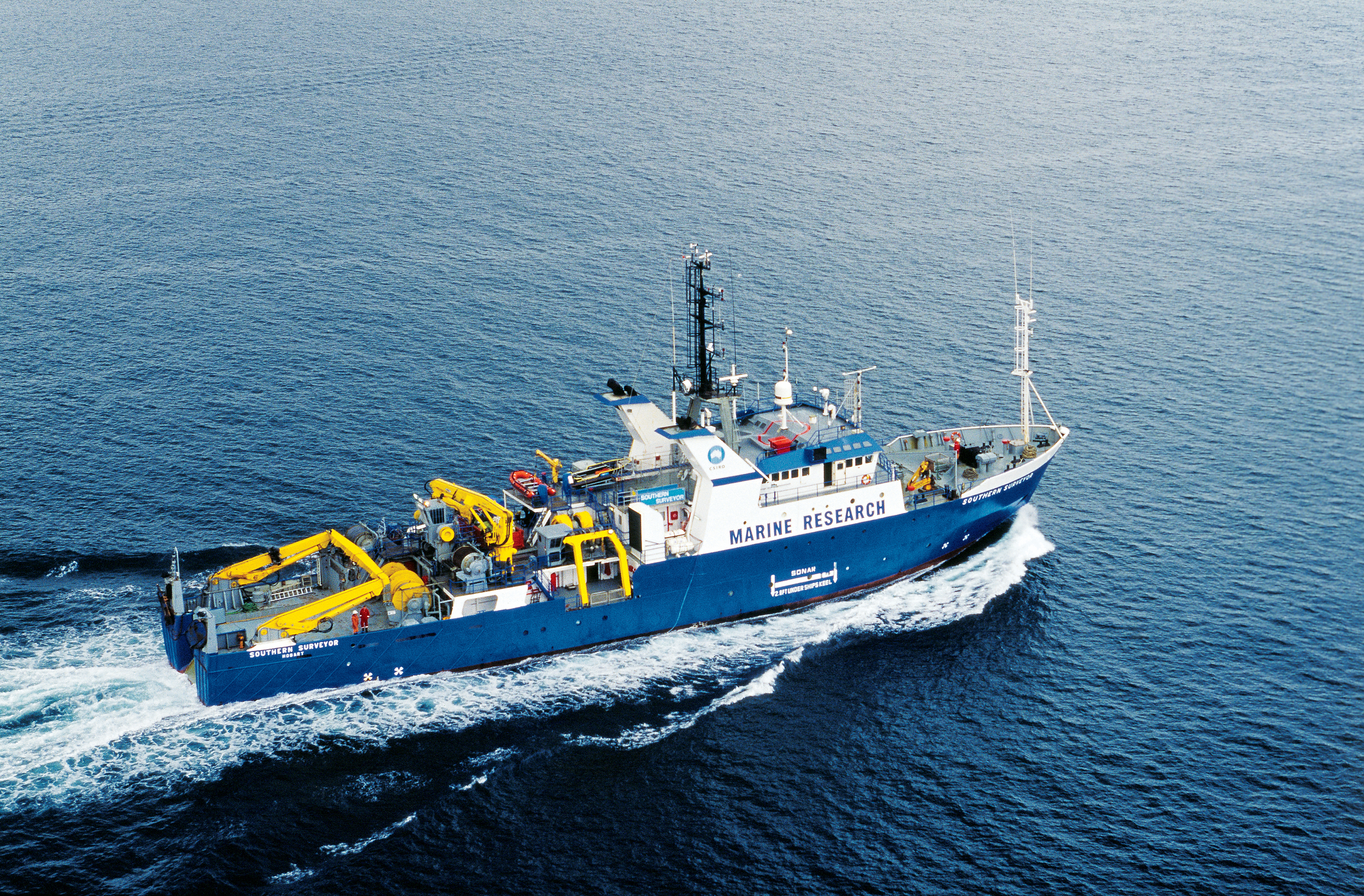
"Well if you think it is somewhere in the Indian or Southern Oceans, somewhere west of Australia, we could use the Marine National Facility to find the source. If you can build a portable radionuclide monitoring station, we could stick it on the RV Southern Surveyor and send it out into the Southern Ocean to find it." Dr. Stocker would respond.
"How would you even do that without the Government knowing?" Dr. Williams would respond.
"Well it only needs Ministerial approval. And you've said the Minister already knows and wants to keep this underwraps as much as we do. He won't tell Cabinet we're doing this. We won't tell Cabinet we're doing this. Everything will work out." Dr. Stocker would respond.
"Well then... cup of tea?" Dr. Williams would ask.
"Milk, no sugar." Dr. Stocker would respond.
To be continued...
Location: Radionuclide Station 10 (RN10), Perth, Western Australia
Geoscience Australia would work alongside the Australian Radiation Protection and Nuclear Safety Agency (ARPANSA) to operate a network of Radionuclide monitoring sites across Australia, originally established as part of Australia's obligations to enforce nuclear weapons test bans, particularly in the Southern Hemisphere. Geoscience Australia would be Australia's leading agency on geoscientific matters and research and would fall under the Department of Industry, Science, Energy and Resources. ARPANSA, however, was part of the Department of Health and was tasked with protecting Australians from both ionising and non-ionising radiation as well as being the regulatory for the use of radiation. After the abolition of nuclear weapons, these sites were repurposed into general particulate monitoring but still retained their radionuclide monitoring capability in order to ensure that Australians were safe from the effects of nuclear radiation. They form part of Geoscience Australia's wider Australian Man-Made Hazard Monitoring Network which also included sites that would detect infrasound, seismic and hydroacoustic explosions. Detections by the radionuclide sites were rare, the closest nuclear power station was in South Africa and it was only the one. Five were located in Argentina and Brazil but were distant enough. The southern latitudes of the Southern Hemisphere were known for their anti-trade winds, or "Westerlies". Winds predominantly moved from west to east, which made southern Australia prone to cold fronts fuelled by Antarctic air during the winter and would traditionally strike South-West Western Australia first.
As the months progressed and winter began settling in for Australia, cold fronts would become a lot more frequent and strong. Strong winds would batter many areas of southern Australia during the winter, as was normal. What wasn't normal though was that the three radionuclide stations of RN10, RN04 and RN07 would begin detecting elevated levels of radiation. This time it was stronger though, the strong winds clearly brought a higher level of radiation with it. The other monitoring stations of the Australian Man-Made Hazard Monitoring Network would detect nothing. No underground seismic explosions. No atmospheric infrasound explosions. No underwater hydroacoustic explosions. This clearly wasn't a re-introduction of nuclear weapons or any nation testing them in the region. The source was still indetermined. Geoscience Australia would continue doing what scientists do, recording down data and monitoring for patterns. ARPANSA, however, was starting to get nervous about the situation. These were the ones who were concerned about the health of Australians, afterall. ARPANSA was eager to start bringing this issue to the Minister for Health and to Cabinet so they could begin measures to protect the Australian public from the fallout of radiation. Geoscience Australia, however, was still wanting to collect data and make a definite determination of the source before such matter was brought to Cabinet. Cabinet had a lot of matters to deal with on a day to day business and was not eager on receiving fluffy information which was incomplete and didn't tell a whole picture.
To Geoscience Australia's displeasure, their departmental rivals, the Commonwealth Scientific and Industrial Research Organisaion (CSIRO) was now also starting to get their fingers into this pie. They operated an air pollution monitoring station called the Cape Grim Baseline Air Pollution Station in the north-west of Tasmania operated alongside the Bureau of Meteorology. It is considered one of only three premier Baseline Air Pollution Stations in the world, alongside Mauna Loa in Hawaii and CFB Alert in the Canadian arctic. The position of the station was ideal because it was able to pick up Westerlies from the Southern Ocean without any interference from landmasses.
Dr. Stocker would place the findings from Cape Grim on the table.
"Did you know about this?"
Dr. Williams would look over the document. He would simply look up at his CSIRO counterpart and stare him blankly in the face.
"Don't be mad, but.... I had a feeling you guys might have discovered this eventually."
"And when did you think was a good time to let anyone know?" Dr. Stocker would respond.
"The Minister knows. What he does with that is above my pay grade. But basically, we don't know the source. The Minister isn't eager on spooking Government or the broader public or increasing scrutiny into this Department for not having answers. Think of what they would do to our budget if they saw we couldn't get them straight answers, John." Dr. Williams would respond.
"Yeah okay, well while you're playing politics my employees are getting agitated about handling massive metal bottles of radiation air and keeping it stored at the archive. Almost every single sample we have from 2008 has elevated levels of radionuclide particles in it."
There would be a momentary pause.
"And I'm sorry about that. And look, ARPANSA is on our fucking ass too about that. Originally they weren't concerned about the amount of radiation Australians were being exposed to. It still is only minute. But with the increase in cold fronts during the winter they're worried that repeated exposures to radiation would have some long-term consequences on the health of Australians. We're holding them off for now from going to the Minister for Health with this, but we're not sure how much longer. And you know once Minister Plibersek gets this news, the horses have well and truly bolted and she would begin ordering lockdowns during high winds under the Radiation Protection and Nuclear Safety Act. Do you want to be forced to stay home all day because the Government is overreacting?" Dr. Williams would continue.
"Well then, Neil. We need to find this source. And fast. Because I'm not going to keep building a stockpile of radiated air at this archive." Dr. Stocker would respond.
"Wherever the source is, it's beyond the borders of Australia. I'm not sure what we could do without getting the Defence Force involved." Dr. Williams would respond.
"Well if you think it is somewhere in the Indian or Southern Oceans, somewhere west of Australia, we could use the Marine National Facility to find the source. If you can build a portable radionuclide monitoring station, we could stick it on the RV Southern Surveyor and send it out into the Southern Ocean to find it." Dr. Stocker would respond.
"How would you even do that without the Government knowing?" Dr. Williams would respond.
"Well it only needs Ministerial approval. And you've said the Minister already knows and wants to keep this underwraps as much as we do. He won't tell Cabinet we're doing this. We won't tell Cabinet we're doing this. Everything will work out." Dr. Stocker would respond.
"Well then... cup of tea?" Dr. Williams would ask.
"Milk, no sugar." Dr. Stocker would respond.
To be continued...